SITE ANALYSIS AND SITE MAPS
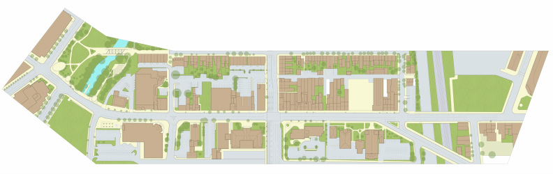
Site Map of Existing Conditions
The current site conditions are indicated generally in plan form in the diagram/ map above. The grey color indicates concrete or asphalt roadways. The light tan color indicates brick or concrete sidewalks. The dark tan indicates building footprints. The aqua-blue color indicates the Assunpink Creek within Mill Hill Park. The light green generally indicates vegetated areas and the darker tanslucent green indicates the existing tree canopies as of Winter 2013.
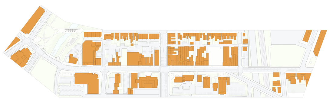
Figure-Ground Diagram of Site Area
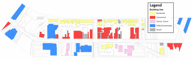
Building-Use Diagram of Site Area
The diagram/ map above indicates the various types of uses of the existing buildings in the site area.
The residential uses along Jackson Street are typically 2-3 story row houses dating from the late 1800’s. Some have been converted into multi-family units but the vast majority are single-occupant dwellings. Parking for these residences is found along the street with regular enforcement of permit parking and alternate side parking on Monday, Tuesday, Thursday, and Friday. The residential use at Market and 323 South Broad Street is the Luther Arms apartments: a twelve story, senior housing facility. Limited parking is found at a surface parking lot behind the building (38 spaces in total).
The commercial uses indicated in red generally consist of retail establishments on the first floor with multifamily housing on the upper level(s). Retail uses include restaurants, small grocery stores, bail bondsmen, and clothing retailers. Office space is also included at the first floor and upper floors in some locations.
The Church and School uses indicated in pink include the Sacred Heart Church at 343 South Broad Street (between Centre Street and Market) and its associated Convent, Social House, Rectory, and School. The Lutheran Church of the Redeemer at 189 South Broad Street is located at Broad and Livingston.
County buildings in the site area include the Historic Mercer County Courthouse (now vacant) at Broad and Market Streets, the adjacent Administrative Building, the Mercer County Civic Courthouse at Broad and Livingston Streets, and the Mercer County Improvement Authority Headquarters at Hamilton Avenue. The Trenton Parking Authority owns the garage at the corner of Front and Broad Streets (it was vacated earlier in 2013 due to structural concerns by the T.P.A.). The State Owned buildings in the site area include the Van Sciver Building at 160 South Broad Street and the eight story headquarters for the New Jersey Department of Community Affairs at Front and Broad Street.
Vacant buildings include the Historic Eagle Tavern at Ferry and Broad Streets, multiple row houses and commercial buildings along Broad Street, Market Street, and Jackson Streets, and a three story office building across the street from the Historic County Courthouse.
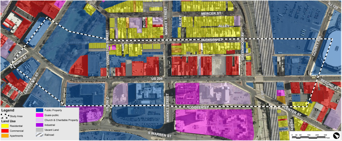
Land Use and Ratables Map of Site Area
The map/ diagram above indicates types of land use according to the color key to the lower left of the image. The largely residential portions of the Mill Hill Historic District (along Jackson and Mercer Streets) are primarily residential with a few exceptions for commercial and church properties. The majority of the even portions of Broad Street between Livingston and US route 1 are Commercial uses. The remainder of the site area is a combination of public property, quasi-public property, and church and charitable properties.
The result of this land use is that the vase majority of the land area in the site area is non-ratable (non-taxable by the City of Trenton). When the right of ways are included in the total land area, less than 15% of the land is ratable in the study area.
The result of this land use is that the vase majority of the land area in the site area is non-ratable (non-taxable by the City of Trenton). When the right of ways are included in the total land area, less than 15% of the land is ratable in the study area.
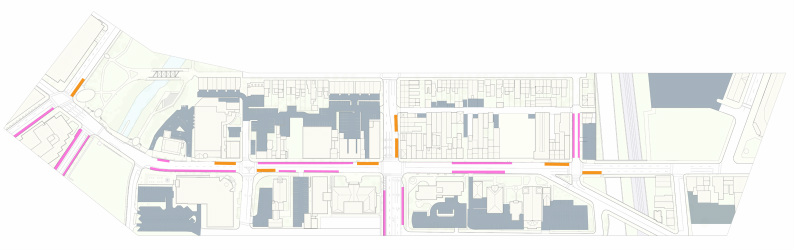
Parking Diagram
The diagram above indicates existing on-street parking spaces (in purple), parking lots in grey, and existing NJ Transit and SEPTA bus stop locations (in orange).
The on-street parking is currently a combination of metered and unmetered spaces. At Front Street, the on-street parking is metered as is East Lafayette Street. Broad Street has metered spaces as indicated on the plan as does the portion of Market Street between Broad Street and New Warren Streets. Greenwood Avenue allows parking except from 4 PM until 6 PM (no parking permit required).
The metered spaces on Broad Street between Market and Front Street have supplemental signage noting that parking is not allowed from 7 AM-9:30 AM Monday-Friday. The spaces are also marked as being hour hour maximum parking from 9:30 AM- 6PM daily. These signs are either incorrect or the parking laws are not enforced. The bulk of the parking spaces are occupied well before 9:30 am daily.
The bulk of the on street parking spaces are taken by cars with handicapped placards hung from the rear view mirror inside the car. NJ State law allows people with the handicapped placards to fill the meter just once and then stay in the space for 24 hours. A 2012 study by the Trenton Downtown Association noted that 96% of the city’s 800 metered on street parking spaces were occupied. Most of the occupied spaces were occupied with vehicles containing the handicapped placards. and the City has found that many of the placard users do not feed the meter at all. The abuse of the system has rendered the city’s parking meter system “revenue neutral”. To make parking matters worse, enforcement of illegal parking spaces (those spaces marked “no parking at any time“ indicated in white above) is not occurring within the site area. During regular weekday business hours, vehicles are parking throughout Broad Street, even at the Assunpink bridge at Mill Hill Park and even at bus stops.
The off street parking areas include a County-owned surface lot behind the Mercer County Civil Courthouse, a lot behind the Sun Bank near Mill Hill Park, a lot adjacent to and owned by the Lutheran Church of the Redeemer, a County-owned lot adjacent to the Mercer County Courthouse Annex, a large city-owned parking lot behind the 200 block of Broad Street (between Broad and Jackson Streets), a series of lots behind the Lutheran Arms Tower and the Church of the Sacred Heart complex, and a small surface lot at Greenwood and Broad Streets. There are also small privately owned lots behind homes and businesses along Conovers Alley and Behind Jackson Street.
The Bus Stops within the area are indicated with pole mounted signage. There are two bus stops with shelters on Broad Street adjacent to Greenwood Avenue and Centre Streets. The remainder of the bus stops do not have formal sitting areas for mass transit riders. The three bus stops located on Market Street and Front Street do not have an area for the bus to pull into so the bus stops in an active lane of traffic. The two stops on Market Street are particularly dangerous because of the speed of the adjacent traffic. On Broad Street, the problems with illegal unenforced parking noted earlier create additional traffic problems when cars park in the designated bus stop areas. The buses are forced to stop in the middle of the only active lane of traffic to pick up and drop off passengers. Also, the two North-bound lanes of traffic on Broad Street between Hamilton Avenue and Greenwood Avenues converge into a single lane at the bus stop location on the even side of the 300 block of Broad Street, creating a dangerous convergence of traffic at a transit stop.
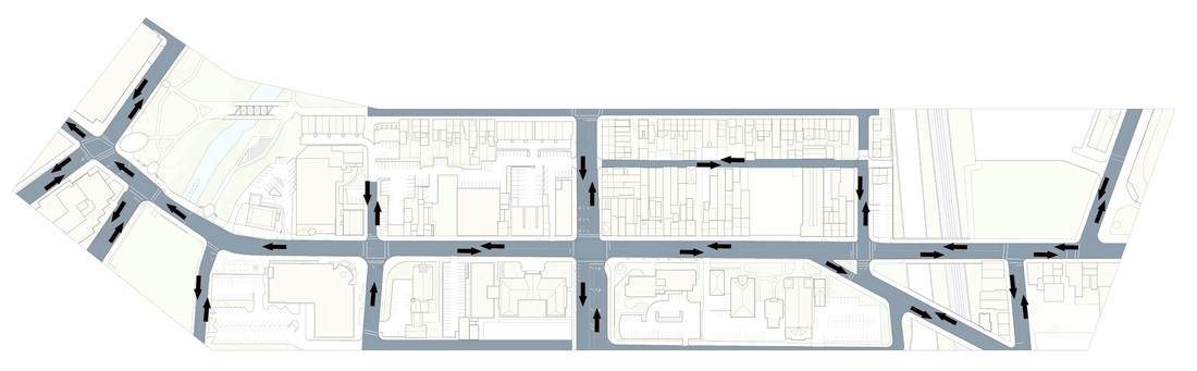
Roadway Diagram
The project site area currently features a combination of one way and two way streets and alleyways of varying widths.
Broad Street is one way from Front Street to Livingston and does not include lane division striping within this area, but cars generally form two lanes of travel. The width varies from being 46’ wide (to the inside face of the curb) at Front Street to 33’ at the Assunpink Creek Bridge. Broad Street transitions to two way traffic from Livingston to Hamilton Avenue with one lane of traffic in each direction up to Centre Street. At Livingston Street, Broad is 38’ wide and at Centre Street it grows to be 45’ wide. At Centre Street, Broad Street transitions to two lanes of traffic in each direction with the lanes indicated with striping. The road width is generally consistent at 40’ in this area.
Market Street has two distinct lanes of traffic in each direction from Jackson Street to Warren Street. It is 56’ wide between Broad Street and Jackson Street. Market is 79’ wide between Broad Street and New Warren Street and it includes a shared turning lane down the middle of the road. This portion of Market also includes 5’ wide bike lanes in each direction but they do not connect to any other bike lanes at Broad Street. The road striping between Broad Street and New Warren Streets was recently installed and is very clear.
Conovers Alley (behind the 300 block of Broad Street) currently features two way traffic along a 20’ road width. Due to the zero-lot-line buildings at Conovers Alley and Market Street as well as the sidewalk there, visibility is very poor for pedestrians and vehicular traffic. There is no road striping along Conovers Alley.
Livingston Street between Broad Street and New Warren Streets currently has two lanes of one way traffic directed towards Broad Street. At the intersection of Livingston and Broad, each lane is a turning lane (either left or right) and traffic can not continue on to the portion of Livingston Street which dead-ends into a parking lot.
Centre Street has two-way traffic with one lane in each direction. At Broad Street, Northbound traffic can not legally turn onto Centre Street. At the same intersection, Greenwood Avenue traffic can not continue straight onto Centre Street.
Signaled intersections in the project area include Front and Broad Streets, Market and Broad Streets, Centre Street Greenwood Avenue and Broad Street, and Hamilton Avenue and Broad Street. All other intersections feature signage controls.
Crosswalks for pedestrians are located at each major road intersection. Curb cuts are also located at most major intersections. Market Street features the most fast-moving traffic due to its expansive width. There has been one fatal vehicular-pedestrian collision at Market Street as well as five non-fatal pedestrian-vehicle collisions in the past eight years. Broad Street has had 14 reported pedestrian vehicle collisions in the site area in the past eight years (most were located near Market Street and Mill Hill Park). See Appendix A for the locations of pedestrian and cyclist accidents in the region taken from 2004-2012.
Bike lane coverage is currently very disconnected. The only bike lanes in the site area are at East Lafayette (one lane in each direction) and at Market Street between Broad Street and New Warren Streets.
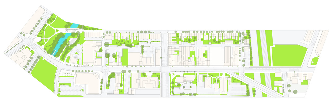
Vegetation, Tree Canopy Diagram
The project site area has a relatively limited pervious coverage of approximately 15-20%. The diagram above indicates the current (as of March, 2013) vegetated areas. On the western edge of the site is Mill Hill Park and the Assunpink Creek. This park is a passive walking park containing pathways , an amphitheater, a steel trestle bridge over the creek, and relatively large grass fields with young and moderate growth trees. The park was renovated in 2012 and additional trees and pathways were added (as shown in the diagram above). South of the park on the other side of Broad Street, the Assunpink Creek enters a concrete culvert and the adjacent area is covered by a field of wild, unmaintained grasses and weeds. Other significant vegetative features include the open lot at Hamilton Avenue and South Broad Street which is currently fenced in as a future development site. This site is porous and also contains wild grasses and weeds. Route 1 and the adjacent Amtrak train right of way are bounded by scrubby brush alongside steep embankments. The rear yards of the homes along Jackson Street contain a rich variety of tree and plant specimens withing a relatively small area. The front Yard of the Sacred Heart Church and adjacent structures contains formal gardens and many decorative trees and shrubs. The Historic Mercer Couty Courthouse also features a decoratively landscaped front yard.
The darker green circles in the diagram approximates the drip line of existing trees in the site area as of March, 2013. The street trees at Broad Street between Market and Front Streets vary in size and spacing. The health of the trees is much better at the two county courthouse sites than the opposing blocks .During a road construction project in 2011, many of the street trees along the 300 block of Broad Street were removed. The 400 block of Broad Street (near Hamilton Avenue) only has a single street treea. Market Street has recently had some trees planted near the new County courthouse but the block of Market between Broad and Jackson Street only has one moderately sized tree and two very small street trees. Many of the trees on this block have recently died.
The surface parking lots in the project area do not feature any vegetated islands to plant additional trees. Likewise, Market Street does not have any vegetated islands between Jackson Street and New Warren Street.
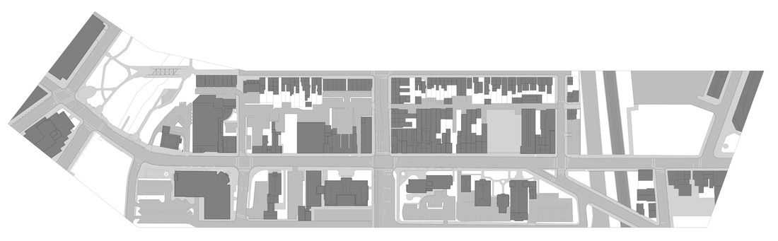
Impervious Coverage Diagram
Impervious coverage refers to materials that do not allow rainwater to penetrate into the subsurface soils. As the project site is located in a dense urban environment, it is not surprising that the site has a relatively high percentage of impervious coverage.
The diagram above indicates impervious pavement in the medium grey tone and impervious building coverage in the darker grey tone. The remaining white areas on the diagram indicate the 15-20% or remaining site area that is pervious with vegetative coverage.
The existing streets within the site area are paved with asphalt and reinforced concrete paving systems and the sidewalks are a combination of brick pavers (over a sand bed and asphalt or concrete base) and poured in place concrete sidewalks. These streets have drains that tie into the City’s underground stormwater drainage network. Concrete and asphaltic surface parking lots are located throughout the site behind buildings, in side yards, and in some cases along the edge of the streets. There are also a few relatively small plazas, patios, and courtyards that are part of both private and public buildings.
The building coverage on the site does not include any known green roofs. The roofing systems vary by building but all of the roofs carry storm water to the City’s underground stormwater drainage system (either directly, or through surface runoff directed towards street drains). Most building roofs are not reflective meaning that most solar heat is absorbed in the roofing membranes.
The concentrated impervious coverage in the site has effectively sealed the soil surface, reducing groundwater recharge. The stormwater runoff is forced into the City’s stormwater management system in which the water is eventually discharged back into waterways without additional particulate or contaminate filtration or other water quality controls. In many locations within the city, the stormwater management system dates from the late 19th century.
The dominance of the impervious coverage also contributes to localized solar heat gain in the summer season. The mass of the impervious materials and thier lack of reflectivity stores radiant heat energy well into the evening. The release of the heat energy throughout the day and at night increases the local air temperature significantly. According to the United States Environmental Protection Agency, roof and pavement surface temperatures can be 50-90 degrees Farenheit hotter than the air, while shaded or moist surfaces remain close to air temperatures. Urban heat islands can be 10-22 degrees Farenheit warmer than adjacent rural areas particularly after sunset (1).
The USEPA also notes that heat islands increases energy use by requiring additional mechanical conditioning. The USEPA has found that 5-10% of summertime urban energy demand is used to compensate for the heat island effect (2). The heat island effect also increases electrical demand at peak hours for utility companies who typically rely on burning fossil fuels for the electricity generation. This further increases air pollutants and greenhouse gases during summer months.
In addition to the elevated energy uses, the higher temperatures increase surface water runoff temperatures, elevating the temperature of nearby streams and rivers.
References:
1. Berdahl P. and S. Bretz. 1997. Preliminary survey of the solar reflectance of cool roofing materials. Energy and Buildings 25:149-158.
2. Akbari, H. 2005. Energy Saving Potentials and Air Quality Benefits of Urban Heat Island Mitigation (PDF) (19 pp, 251K). Lawrence Berkeley National Laboratory.